Jhagadia Fm
Type Locality and Naming
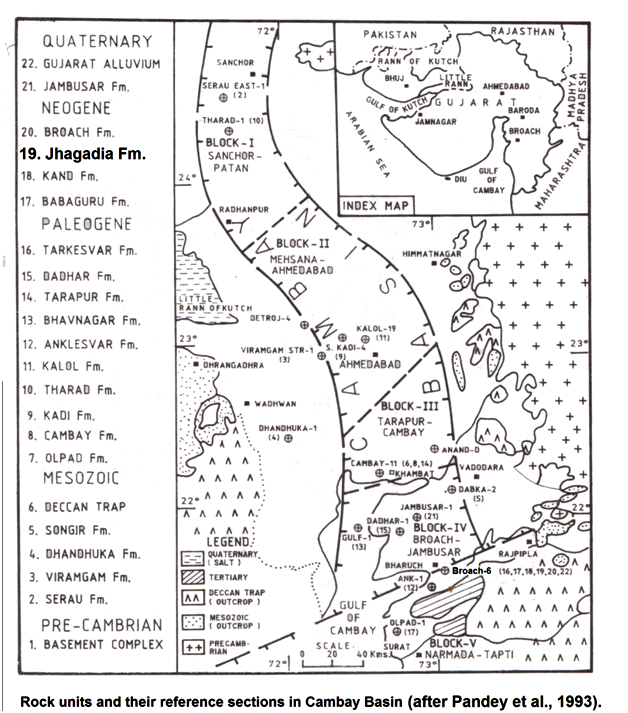
SUBSURFACE: Named after Jhagadi village. Well Broach-6 (depth interval 1728-1952m), It is of 224 m thickness. [Original Publication: Sudhakar, R. and Roy, T.K. (1959) Progress report on the geology of the tertiary formations of Broach and Surat districts (1958-59). Unpublished report of ONGC.]. The nomenclature of this formation was given by the above authors after the outcropping sections observed near Jhagadia Village during field mapping. Reference well: i) Pakhajan-1 (depth interval 1680-1924 m); ii) Dadhal-1 (depth interval 145 – 289 m); iii) Cambay-40 (depth interval 650 – 885 m); iv) Nawagam-22 (depth interval 405 – 695 m), In Pakhajan-1, the thickness is 244m while in Dadhala-1, in Cambay-40 and Nawagam-22 the thickness is 144m, 235m and 290m, respectively.
Lithology and Thickness
Sandy claystone. In the type section, the formation consists of alternations of chocolate brown to reddish-brown claystone, sandy claystone and sandstone. In reference section, the formation consists of alternations of brown to reddish-brown claystone and sandstone. The maximum thickness has been encountered in the type section which is 928 m in Broach-6. The thickness in reference section i.e. Pakhajan-1, Siswa-1 and Nawagaon-22 is 849 m, 310 m and 150 m.
[Figure 1: Rock units and their reference sections in Cambay Basin (after Pandey et al., 1993)]
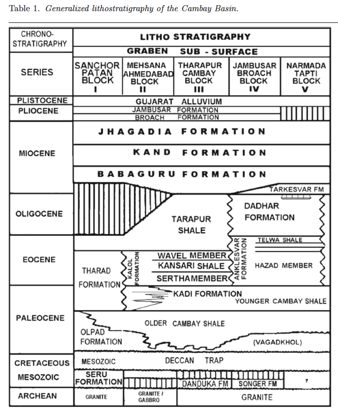
[Figure 2: Generalized stratigraphy of the Cambay Basin. (from Jaiswal and Bhattacharya, 2018, J.EarthSyst.Sci., 127:65)]
Relationships and Distribution
Lower contact
Lower boundary is unconformable with the underlying Tarkeswar Fm (south), Babaguru Fm (central) or Kand Fm (north)
Upper contact
Throughout the basin, unconformably overlain by GujaratAlluvium Fm or the Jambusar Fm (or Broach Fm locally).
Regional extent
The formation extends throughout the Cambay Basin.
GeoJSON
Fossils
The formation is poorly fossiliferous in the subsurface and unfossiliferous in the outcrops.
Age
Depositional setting
Additional Information

